Mapping 13 Kilometers of Underground Technical Galleries in Brussels
Key Benefits at a Glance
|
Safety Exploring the underground galleries involved unknown risks such as exposed wiring, old equipment, and hazardous materials. Traditional inspection methods were not only time-consuming but also risky. The Elios 3 provided a safe alternative, allowing teams to collect data without exposing themselves to dangerous environments. |
Speed The use of the Elios 3 enabled rapid data collection across various types of underground spaces—confined areas, open sections, and around pipe racks. This significantly reduced the time needed to survey 13 kilometers of technical galleries, making the process much more efficient. |
|
Data Quality The Elios 3, equipped with a LiDAR payload, was used over 9 intense days for 241 flights. A total of 1,776 points of interest were recorded and analyzed by experts to assess the condition of the galleries accurately. |
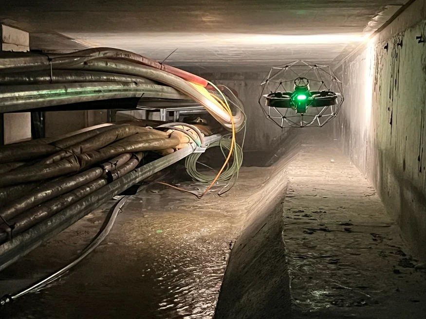
Access Many of the underground galleries had water pools or very tight spaces, making them difficult to access. The Elios 3 proved highly adaptable, capable of navigating these challenging environments with ease and providing critical insights without the need for physical entry. |
Brussels is one of Europe's most influential cities, home to the European Commission and a vibrant international community. Known as the "Capital of Europe," it’s an ideal place to implement smart city initiatives. Smart cities rely on technology to collect and analyze data, optimizing everything from traffic systems to green infrastructure. Effective smart city management requires a combination of advanced technology, system optimization, and thorough asset management.
To support this vision, the Maintenance and Inspection Department at Brussels Mobility launched a project to survey and map the underground technical galleries beneath the city. These galleries, some built decades ago, lacked up-to-date records. The goal was to create a detailed inventory of the spaces, their contents, and necessary maintenance, enabling better planning and utilization of the underground infrastructure.
Building a Specialized Underground Survey Team
Although the presence of the underground galleries was known, their exact locations, sizes, and connections were not fully understood. Brussels Mobility aimed to create a comprehensive record of these spaces to inform future maintenance and usage strategies. Without accurate blueprints, they needed to gather real-time data to build an as-built model of the network.
Brussels Mobility partnered with several companies to conduct the survey. They sought specialists in data collection and processing who could navigate uncharted, potentially hazardous environments. SECO, an engineering and construction firm, was among the first to join. Their role included inspecting concrete structures and supporting data collection efforts in confined spaces.
Sweco, a leading engineering and architecture consultancy, was tasked with creating an inventory of utility-related underground structures. They used LiDAR and visual imagery to generate detailed 2D maps and 3D cross-sections of the spaces. Medexon and Flywel, drone inspection specialists, brought the Elios 3 into the mix—ideal for inspecting hard-to-reach and potentially dangerous areas.
 The project required a team of experts to ensure safe and accurate data collection in complex underground environments.

With the right team in place, the project began. The main objectives were to gather data on unknown areas, identify assets, and detect structural issues like concrete cracking. The Elios 3 played a crucial role in all these tasks, helping the team navigate through complex and often dangerous environments safely and efficiently.
Underground Surveys Using the Elios 3
The data collection team faced many challenges during the survey. Some galleries had no prior records, while others contained hazards like electrical cables in water or blocked pathways. The Elios 3 was essential in scouting these areas before any human entry, ensuring safety and efficiency.
Over 200 flights were conducted in cold conditions, covering 13 kilometers of underground spaces. The drone collected both LiDAR and visual data, which was then processed to create detailed maps. In some cases, the Elios 3 was held manually to capture data where flying wasn’t possible, showcasing its versatility.
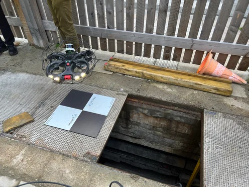
Image right: The Elios 3 provided a safer and faster way to explore and map underground spaces compared to traditional methods.
Complex Mapping Made Easier with a Drone
Despite the challenges, the Elios 3 proved to be a game-changer. It allowed the team to map 13 kilometers of underground spaces, including storm drains and technical rooms, with remarkable accuracy. Over 241 flights were completed in just nine days, capturing 1,776 points of interest that were later analyzed by experts.
The data processing was a huge task, especially when dealing with drift in LiDAR datasets. However, with collaboration between the teams and the Flyability engineers, the results were optimized. Sweco created a detailed LiDAR map overlaid with surface data, giving a clear view of the underground assets in relation to the above-ground environment.
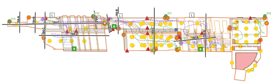 The final maps are precise and ready to support future maintenance and planning efforts.
This project has been ongoing for over a year, with strong collaboration between all the teams involved. It has successfully gathered comprehensive and actionable data for Brussels Mobility, allowing them to plan the future of these underground spaces effectively.
In the future, the data will be shared with utility companies to assist with maintenance and repairs, as well as help repurpose the galleries for public use. Drones like the Elios 3 have proven invaluable in making underground surveys faster, safer, and more efficient—especially in GPS-denied environments.
Medexon-Flywel is confident in the Elios 3’s capabilities for future projects, especially with the new Surveying Payload that enhances its performance in challenging settings.
Discover more about the Elios 3 and its specialized LiDAR payload.
All images in this article are credited to CLP Power.
Low Pressure Cryogenic Liquid Tanks
Low Pressure Cryogenic Liquid Tanks,Cryogenic Oxygen Tanks,Cryogenic Gas Cylinders,Liquid Nitrogen Storage Tanks
CBM TECHNOLOGIES (NINGBO) CO.,LTD , https://www.sinogascylinders.com